Upstate WildEye operates within all FAA Part 107 regulations and New York State DEC laws.

Wildlife Assessments


Upstate WildEye brings the power of modern thermal drone technology to the properties of Upstate New York. We provide landowners with a complete, non-invasive assessment of their property. Our low-noise propellers and high-resolution thermal cameras ensure that we can accurately count population species, analyze buck/doe ratios, and map terrain details without "bumping" or spooking the wildlife. We offer 2 packages to choose from ranging from basic animal observations to a full scale property interactive map.
View Our Options Below!

Accurate wildlife counts for your property. Get the fundamental data you need to start planning.This package provides an accurate, aerial census of your land. In 3 hours of flight time we fly your property. Watch the action live on our on-site TV and confirm exactly what's on your land before you ever step foot. Perfect for getting a quick, verified baseline count and confirming animal density.


Essential Package
Note: Price Per 150 acres
- Up to 3 Hour Flight ✅
- Number of Animals Recorded ✅
- Small TV for best Viewing ✅
Know Your Numbers Quickly
- Pinned Animal Locations ✅


Property Management Package
Go beyond the basics. This is the ultimate tool for serious property owners trying to maximize their property. Our extended 4 hour flight delivers a wealth of critical data. Utilizing high end mapping software, we provide a full 3D high resolution map including a variety of valuable information listed below. Perfect for making highly informed land decisions.


Note: Price Per 150 acres
Land Intelligence at its Best
- Up to 4 Hour flight ✅
- Color-Coded Buck/Doe Ratio pins ✅
- 3D Terrain Assessment/Contour lines ✅
- Soil Information & Type ✅
- Small TV for best Viewing ✅
- Flood Risk Zones ✅
- Marked Features (Existing food plots, tree stands, and buildings) ✅
- Property Lines & Acreage ✅
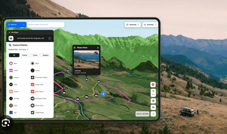

High Resolution Map Includes...